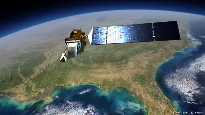
Landsat 8 (formerly called the Landsat Data Continuity Mission, or LDCM) is NASA’s eighth satellite in the Landsat series and continues the Landsat program’s critical role in monitoring, understanding and managing the resources needed for human sustainment such as food, water and forests. As our population surpasses seven billion people, the impact of human society on the planet will increase, and Landsat monitors those impacts as well as environmental changes.
Landsat 8 joined the Landsat 7 satellite in orbit and produces stunning pictures of Earth’s surface along with a wealth of scientific data. Landsat 8 measures Earth’s surfaces in the visible, near-infrared, short wave infrared and thermal infrared, with a moderate-resolution of 15 to 100 meters, depending on spectral frequency.
Landsat 8 carries two instruments:
• The Operational Land Imager (OLI) sensor includes refined heritage bands, along with three new bands: a deep blue band for coastal/aerosol studies, a shortwave infrared band for cirrus detection, and a Quality Assessment band.
• The Thermal Infrared Sensor (TIRS) sensor provides two thermal bands. These sensors both provide improved signal-to-noise (SNR) radiometric performance quantized over a 12-bit dynamic range. (This translates into 4096 potential grey levels in an image compared with only 256 grey levels in previous 8-bit instruments.) Improved signal to noise performance enable better characterization of land cover state and condition. Products are delivered as 16-bit images.
Landsat 8 is a collaboration between NASA and the U.S. Geological Survey (USGS).
For more information:https://landsat.usgs.gov/landsat-8
Providing moderate-resolution imagery, from 15 meters to 100 meters, of Earth land surface and polar regions, Landsat 8 operates in the visible, near-infrared, short wave infrared, and thermal infrared spectrums. Landsat 8 captures approximately 400 scenes a day, an increase from the 250 scenes a day on Landsat 7. The OLI and TIRS sensors have improved signal to noise (SNR) radiometric performance, enabling 12-bit quantization of data allowing for more bits for better land-cover characterization.
Pixel size:
15 meters/30 meters/100 meters (panchromatic/multispectral/thermal)
OLI: 12 meters circular error, 90-percent confidence
TIRS: 41 meters circular error, 90-percent confidence
Operational Land Imager (OLI)
Landsat 8 Operational Land Imager (OLI) improves on past Landsat sensors and was built, under contract to NASA, by Ball Aerospace. OLI uses a technological approach demonstrated by the Advanced Land Imager sensor flown on NASAs experimental EO-1 satellite. The OLI instrument uses a pushbroom sensor instead of whiskbroom sensors that were utilized on earlier Landsat satellites. The pushbroom design results in increased sensitivity, fewer moving parts, and improved land surface information.
OLI collects data from nine spectral bands. Seven of the nine bands are consistent with the Thematic Mapper (TM) and Enhanced Thematic Mapper Plus (ETM+) sensors found on earlier Landsat satellites, providing for compatibility with the historical Landsat data, while also improving measurement capabilities. Two new spectral bands, a deep blue coastal / aerosol band and a shortwave-infrared cirrus band, will be collected, allowing scientists to measure water quality and improve detection of high, thin clouds.
| Spectral Band | Wavelength | Resolution |
|---|---|---|
| Band 1 - Coastal / Aerosol | 0.433 - 0.453 µm | 30 m |
| Band 2 - Blue | 0.450 - 0.515 µm | 30 m |
| Band 3 - Green | 0.525 - 0.600 µm | 30 m |
| Band 4 - Red | 0.630 - 0.680 µm | 30 m |
| Band 5 - Near Infrared | 0.845 - 0.885 µm | 30 m |
| Band 6 - Short Wavelength Infrared | 1.560 - 1.660 µm | 30 m |
| Band 7 - Short Wavelength Infrared | 2.100 - 2.300 µm | 30 m |
| Band 8 - Panchromatic | 0.500 - 0.680 µm | 15 m |
| Band 9 - Cirrus | 1.360 - 1.390 µm | 30 m |
Thermal InfraRed Sensor (TIR)
The Thermal InfraRed Sensor (TIRS), built by the NASA Goddard Space Flight Center, conducts thermal imaging and supports emerging applications such as evapotranspiration rate measurements for water management. The TIRS data is being registered to OLI data to create radiometrically, geometrically, and terrain-corrected 12-bit Landsat 8 data products. Like OLI, TIRS employs a pushbroom sensor design in addition to a 185 kilometer cross-track field of view. Data for two long wavelength infrared bands will be collected with TIRS; however, TIRS only provides Landsat data continuity with one band--Band 10. With TIRS being a late addition to the Landsat 8 satellite, the design life requirement was relaxed in order to expedite development of the sensor. As such, TIRS only has a three-year design life.
| Spectral Band | Wavelength | Resolution |
|---|---|---|
| Band 10 - Long Wavelength Infrared | 10.30 - 11.30 µm | 100 m |
| Band 11 - Long Wavelength Infrared | 11.50 - 12.50 µm | 100 m |
 |
 |
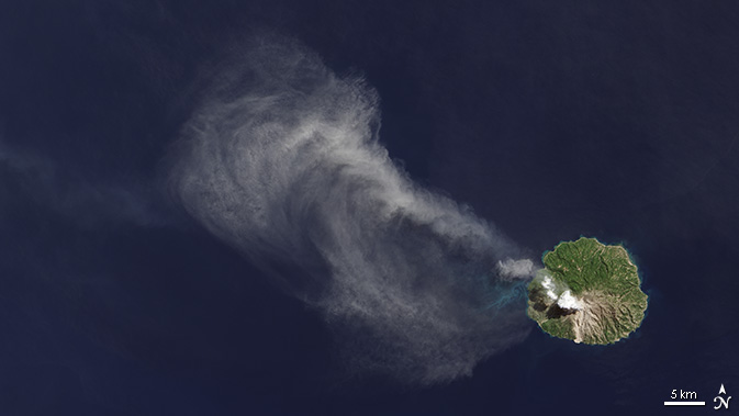
| An ash plume drifts from Paluweh volcano in Indonesia in this image, taken April 29, 2013 from the Landsat Data Continuity Misison‘s Operational Land Imager instrument. Credit: Robert Simmon, NASA‘s Earth Observatory, using data from USGS and NASA |
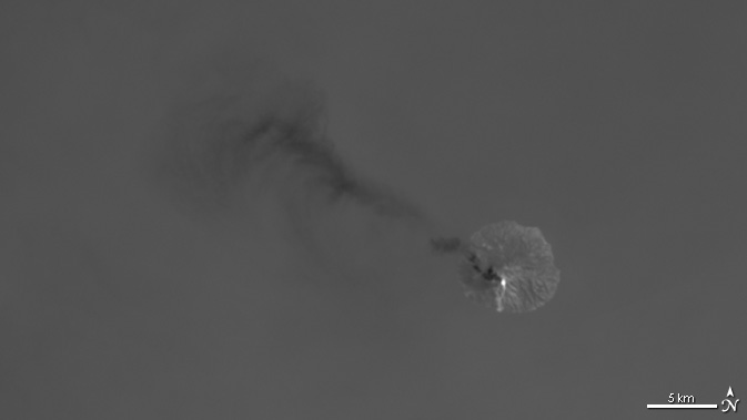
A bright white hot spot, surrounded by cooler dark ash clouds, shows the volcanic activity at Paluweh volcano in the Flores Sea, Indonesia. This thermal image was taken by the Landsat Data Continuity Mission‘s Thermal Infrared Sensor on April 29, 2013. Credit: Robert Simmon, NASA‘s Earth Observatory, using data from USGS and NASA |
 |
 |
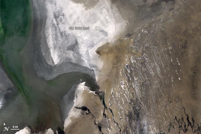
| Clouds are hard to spot in this natural-color image of the Aral Sea in Central Asia, taken March 24, 2013. Credit: NASA Goddard/Landsat/Michael Taylor |
A new band on the Landsat Data Continuity Mission satellite detects cirrus clouds, making these high-altitude clouds visible over the Aral Sea region on March 24, 2014. Credit: NASA Goddard/Landsat/Michael Taylor |