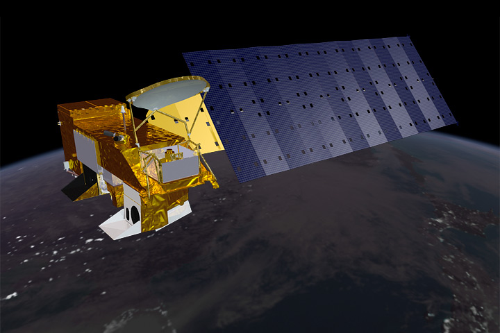
The Focus for the Aqua Project is the multi-disciplinary study of the Earth’s Interrelated Processes (atmosphere, oceans, and land surface) and their relationship to earth system changes. The global change research emphasized with the Aqua instrument data sets include: atmospheric temperature and humidity profiles, clouds, precipitation and radiative balance; terrestrial snow and sea ice; sea surface temperature and ocean productivity; soil moisture; and the improvement of numerical weather prediction.
Vital Statistics
Weight - 6,468 pounds
Power - 4,444 watts orbit average
Size- 260 inches long; 102 inches in diameter
Mission Life Goal - 6 years Orbit
Sun - synchronous, polar
Altitude - 705 km nominal
Inclination - 98.2 0.1 degrees
Ascending node - 1:30 p.m. 15 minutes
Period - 98.8 minutes Instruments
Atmospheric Infrared Sounder (AIRS)
The AIRS is a high resolution instrument which measures upwelling infrared (IR) radiances at 2378 frequencies ranging from 3.74 and 15.4 micrometers. A limited number of visible wavelength channels are also present. AIRS is being developed by Lockheed Martin Infrared Instrument Systems (LMIRIS) under a contract from the NASA Jet Propulsion Laboratory (JPL). AIRS, in conjunction with AMSU and HSB, will provide significant improvements in the accuracy of several climate and weather parameters. See AIRS instrument at http://www-airs.jpl.nasa.gov for further details.
Advanced Microwave Sounding Unit (AMSU)
The AMSU is a passive scanning microwave radiometer consisting of two sensor units, A1 and A2, with a total of 15 discrete channels operating over the frequency range of 50 to 89 GHZ. The AMSU operates in conjunction with the AIRS and HSB instruments to provide atmospheric temperature and water vapor data both in cloudy and cloud-free areas. AMSU is being developed by Aerojet under a contract from NASA GSFC. See AMSU instrument at http://aqua.nasa.gov/about/instrument_amsu.php for further details.
Advanced Microwave Scanning Radiometer-EOS (AMSR-E)
The AMSR-E is a passive forward-looking scanning microwave radiometer with 6 discrete frequencies in the range of 6.9 to 89 GHZ. AMSR-E is being developed by Mitsubishi Electric Corporation under a contract from National Space Development Agency of Japan (NASDA). The AMSR-E data will be used to provide precipitation rate, water vapor content, and surface moisture content. See AMSR-E instrument at http://aqua.nasa.gov/about/instrument_hsb.php for further details.
Clouds and the Earth’s Radiant Energy System (CERES)
The CERES instrument is a broadband scanning radiometer, with three detector channels, 0.3 to 5.0 micrometers, 8.0 to 12.0 micrometers and 0.3 to 50 micrometers. Two CERES instruments are in the Aqua payload suite. One instrument operates in the crosstrack mode for complete spatial coverage from limb to limb; the other with a rotating scan plane (biaxial) mode to provide angular sampling. Both instruments are capable of operating in either mode. CERES is being developed by TRW under a contract from NASA LaRC. See CERES instrument at http://asd-www.larc.nasa.gov/ceres/ASDceres.html for further details.
Humidity Sounder for Brazil (HSB)
The HSB is a passive scanning microwave radiometer with a total of 5 discrete channels operating in the range of 150 to 183 GHZ. The HSB data are used in conjunction with the AIRS data to provide humidity profile corrections in the presence of clouds. HSB is being developed by Matra Marconi Space under a contract from Instituto Nacional de Perquisas Espacias (INPE), Brazil. See HSB instrument at http://www.dss.inpe.br/programas/hsb/ingl/index.html for further details.
Moderate Resolution Imaging Spectroradiometer (MODIS)
The MODIS instrument is a passive imaging spectroradiometer. The instrument scans a cross-track swath of 2330 km using 36 discrete spectral bands between 0.41 and 14.2 micrometers. The MODIS will provide imagery of the Earth’s surface and cloud cover to develop an improved understanding of global dynamics and processes occurring on the surface and in the lower atmosphere. MODIS is being developed by Raytheon/Santa Barbara Remote Sensing under a contract from NASA GSFC. See MODIS instrument at http://ltpwww.gsfc.nasa.gov/MODIS for further details
Please visit http://aqua.nasa.gov/ for further information.
Aqua is focused on the multi-disciplinary study of Earth’s interrelated processes (atmosphere, oceans, and land surface) and their relationship to changes in the Earth system. The global change research efforts emphasized with the Aqua instrument data sets include atmospheric temperature and humidity profiles, clouds, precipitation and radiative balance; terrestrial snow and sea ice; sea surface temperature and ocean productivity; soil moisture; and the improvement of numerical weather prediction. Aqua is also making critical contributions to the monitoring of terrestrial and marine ecosystem dynamics.
|
|
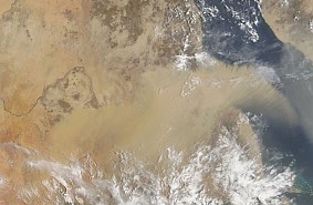
This MODIS Terra image, acquired July 25, 2006, shows a dust storm blowing off the coast of Sudan (left), out over the Red Sea. The Red Sea separates the African countries like Egypt, Sudan, and Ethiopia from Saudi Arabia. Extreme summer heat increases the likelihood of dust storms, and the sand seas of the Middle East produce many of the planets dust plumes. There have been a number of dust storm in this region over the summer, including those on June 28, June 21, and June 9. |
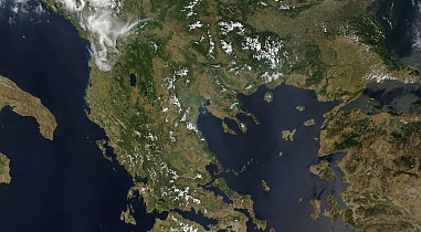 |
Sensor: Terra/MODIS Bands: 1,4,3 Date: 02.08.2006 |