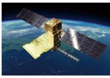
•Monitoring land deformation and subsidence
•A radar satellite can measure diastrophism or ground transformation caused by volcanic activity or an earthquake up to a few centimeters by comparing acquired data in the same area at different times. For example, the location of a magma reservoir and its movement from surface displacement can be estimated by continuously monitoring volcanoes, and such an estimation can contribute to understanding volcanic activities. Data to be acquired by ALOS-4 will also be used for comparison with data acquired by DAICHI-2, which flies on the same orbit, to investigate changes.
If DAICHI-2 tries to cover all active volcanoes in Japan, it can observe one volcano just four times a year, hence more frequent observations would be performed only if a certain volcanic activity gets more active. ALOS-4 will increase the observation frequency to once every two weeks so that disaster prevention agencies can find abnormal changes such as unusual volcanic activity, land subsidence, or landslides at an early stage to timely warn people nearby. In addition, the observation swath will be drastically increased from 50 km to 200 km while keeping the high resolution, as you can see in Figure 1. Therefore, we can observe a broader area at the same time when a large-scale disaster that damages wide areas occurs, such as a huge earthquake or multiple eruptions at the same time.
ALOS-2 vs ALOS-4 Image swath Comparison

APPLICATIONS:
- Environmental monitoring
- Disaster monitoring
- Civil planning
- Agriculture and forestry
- Earth resources
- Observing Land surface
ALOS-4 TECHNICAL SPECIFICATIONS:
|
Sensor Type |
L-band synthetic aperture radar (PALSAR-3) |
|
Launching Year |
Planned in 2020 |
|
Orbit Type |
Sun-synchronous sub-recurrent orbit |
|
Orbit Altitude |
628 km |
|
Revisit |
14 days |
|
Band |
L-Band |
|
Frekans |
1.2 GHz |
|
Observation Modes |
Spotlight Mode: Resolution: 1m x 3m, Swath: 35km x 35km |
|
Stripmap Mode: Resolution: 3m (max) 6m, 10m, Swath: 100 -200km |
|
|
ScanSAR Mode: Resolution 25m (max), Swath: 700km |
|
|
Design Life Time |
7 years |
