
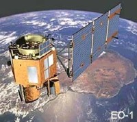
The NASA Earth Observing-1 (EO-1) satellite was launched on November 21, 2000 as part of a one-year technology validation/demonstration mission. The original EO-1 mission was successfully completed in November 2001. As the end of the mission approached, the remote sensing research and scientific communities expressed high interest in continued acquisition of image data from EO-1. Based on this user interest, an agreement was reached between NASA and the USGS to allow continuation of the EO-1 Program as an Extended Mission.
The EO-1 Extended Mission is chartered to collect and distribute Advanced Land Imager (ALI) multispectral and Hyperion hyperspectral products in response to Data Acquisition Requests (DARs). Under the Extended Mission provisions, image data acquired by EO-1 are archived and distributed by the USGS EROS Data Center (EDC) and placed in the public domain. The EO-1 spacecraft follows Landsat 7 by approximately one minute. It is capable of cross-track pointing to allow potential imaging within one full adjacent WRS path in each direction from the current flight path. Each ALI scene covers approximately one-fifth the width of a Landsat 7 ETM+ scene. Hyperion scenes are acquired in strips, with a cross-track width of 7.7 km. Imagery from either sensor will have a user-specified along-track length of either 42 km or 185 km (equivalent to one full Landsat 7 ETM+ scene length).
March 16, 2017: After 17 years in orbit, one of NASA s pathfinder Earth satellites for testing new satellite technologies and concepts comes to an end on March 30, 2017. The EO-1 (Earth Observing-1) satellite will be powered off on that date but will not enter Earth s atmosphere until 2056.
For more information please visit: http://eo1.gsfc.nasa.gov/miscPages/home.html
The NASA Earth Observing-1 (EO-1) satellite was launched on November 21, 2000 as part of a one-year technology validation/demonstration mission. The original EO-1 mission was successfully completed in November 2001. As the end of the mission approached, the remote sensing research and scientific communities expressed high interest in continued acquisition of image data from EO-1. Based on this user interest, an agreement was reached between NASA and the USGS to allow continuation of the EO-1 Program as an Extended Mission.
The EO-1 Extended Mission is chartered to collect and distribute Advanced Land Imager (ALI) multispectral and Hyperion hyperspectral products in response to Data Acquisition Requests (DARs). Under the Extended Mission provisions, image data acquired by EO-1 are archived and distributed by the USGS EROS Data Center (EDC) and placed in the public domain. The EO-1 spacecraft follows Landsat 7 by approximately one minute. It is capable of cross-track pointing to allow potential imaging within one full adjacent WRS path in each direction from the current flight path. Each ALI scene covers approximately one-fifth the width of a Landsat 7 ETM+ scene. Hyperion scenes are acquired in strips, with a cross-track width of 7.7 km. Imagery from either sensor will have a user-specified along-track length of either 42 km or 185 km (equivalent to one full Landsat 7 ETM+ scene length).
March 16, 2017: After 17 years in orbit, one of NASA s pathfinder Earth satellites for testing new satellite technologies and concepts comes to an end on March 30, 2017. The EO-1 (Earth Observing-1) satellite will be powered off on that date but will not enter Earth s atmosphere until 2056.
For more information please visit: https://eo1.gsfc.nasa.gov/
|
|||||||||||||||||||||||||||