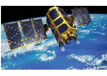
The Republic of Kazakhstan is utilizing the latest Earth Observation (EO) satellite technologies from EADS Astrium and its subsidiary SSTL to create a national system which supports its government with resource monitoring, resource management, land-use mapping and environmental monitoring information for policy and decision making. The new ERSSS (Earth Remote Sensing Satellite System) includes a high resolution mapping spacecraft and a wide-swath medium resolution multispectral mapping spacecraft implemented by a team comprising Astrium and SSTL.
The SSTL KazEOSat 2 satellite, formerly known as MRES (Medium Resolution Earth Observation Satellite), delivers wide swath multispectral imagery of the Kazakh territory and other parts of the Earth. It weighs 177 kg and have the capability to image and downlink one million square kilometers per day, with exceptionally agile off-pointing capabilities for this class of satellite.
- Active lifetime period, years – 7;
- Spatial resolution in multispectral mode, 6.5m.
- Number of multispectral channels – 5;
Imaging Modes:
|
Imaging mode |
Imaging possibilities |
|
Strip mode is conducted for the imaging along the route of the spacecraft with width of 77 km and length from 77 km to 4000 km.
|
|
|
Area mode Consists of two adjacent strips of 77 km width and 90 km length
|
|
|
Stereo mode is conducted along the maneuver of the spacecraft with possibility to make images of the same territory (object) with different imaging angles with width of 77 km and length of 90 km. |
|
Data Product Levels:
L1A (1A): Digital satellite imagery, after applying of radiometric correction. Images are not given to any projection, but all information saved in accompanied metadata file.
L2A (2А): Digital satellite imagery, acquired with the use of radiometric, geometric correction. Images are given to a cartographic projection.
L3 (3А): Digital satellite imagery, including radiometric, acquired with the use radiometric, geometric correction. Images are given to a cartographic projection. Images are orthorectified (image amended for relief) using a digital elevation model (DEM) and ground control points (optionally, if applicable).
L4 (-): Digital elevation model (DEM) and digital terrain model (DTM) are given to a cartographic projection.
L5 (3В): Mosaic, created from L3 or L4 products.
Daha fazla bilgi için: http://gharysh.kz/en/
Characteristics of spacecraft KazEOSat-2
|
Aperture diameter |
145 мм |
|
Focus distance |
633 мм |
|
Spectral bands |
blue - 0.45-0.52 µm |
|
Spatial resolution (GSD) |
6,5 м (in nadir) |
|
Pixel quantization |
12 bit |
|
Swath width |
77 km |
|
Deflection from Nadir |
+/- 35 º |
|
Mass of payload imager |
45kg |
|
Ability to make stereo pairs |
Yes, in one cycle |


