THEOS (THai Earth Observation System) will be fully owned and operated by the Thai Ministry of Science and Technology’s Space Agency (GISTDA) and will provide Thailand with worldwide geo-referenced image products and image processing capabilities for applications in cartography, land use, agricultural monitoring, forestry management, coastal zone monitoring and flood risk management. THEOS will provide access to any part of Thailand in less than 2 days.
Theos was launched succesfully on the date of 01 October,2008 from Yasny, Russian Federation.
The satellite, which provides resolution at two metres and has a map accuracy of 1:10000 scale that can be used for economic and social purposes.
The data can be used for base maps and utilised for many other applications. It is already used for geoinformatics, showing rice, tapioca and maize crop areas that support the government’s agricultural policy.
For more information: http://www.gistda.or.th/main/en
Technical Specifications:
|
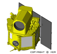
Launch mass |
715 kg. |
|
Dimensions |
2.1 m. x 2.1 m. x 2.4 m. |
|
Solar array |
840 Watt |
|
Hydrazine |
82 kg. |
|
Recording capacity |
51 Gbit (BOL) solid-state memory |
|
Onboard image processing |
2.8 or 3.75 compression ratio (DCT) |
|
Image telemetry |
120 Mbit/s (X band) |
|
Attitude control |
Earth pointing and high agility |
|
Orbit determination |
GPS |
|
Payload |
1 PAN and 1 MS cameras |
|
Orbit |
Sun-synchronous (14+5/26 orbits per day) |
|
Inclination |
98.7° |
|
Altitude at equator |
822 km |
|
Period |
101.4 min |
|
Local equator crossing time |
10:00 am (Descending) |
|
Sub-satellite point velocity |
6.6 km/s |
|
Nominal life time |
5 years |
Sensors:
|
Panchromatic |
Multispectral |
|
|
Wavelength |
P : 0.45 - 0.90 µm |
B0 (blue) : 0.45 - 0.52 µm |
|
Resolution |
2 m. |
15 m. |
|
Swath width |
22 km. (nadir) |
90 km. (nadir) |
|
Number of pixels |
12,000 pixels |
6,000 pixels |
|
Access corridor width |
1,000 km. |
1,100 km. |