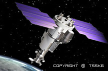
Resurs-DK1 is Russia′s first civil EO (Earth Observation) imaging satellite capable of transmitting high-resolution imagery (1 m) to the ground stations as it passes overhead. The spacecraft was designed and built by TsSKB Progress (State Research & Production Space Rocket Center) of Samara (the Samara Space Center location is on the Volga River, about 1000 km southeast of Moscow). Roskosmos is funding the project (owner and operator of the spacecraft), the commercial data distributor is Sovzond JSC of Moscow. The spacecraft is operated by Russia′s Science Center for Remote Sensing of Earth, NTs OMZ.
The satellite is designed for multispectral and spectrozonal mapping of the Earth′s surface in the visible and near IR bands (high terrain resolution and improved geometry and photometry performance, augmented by real-time downlink data transmission). Its data will enable update and improvement of the existing geographic digital maps, offer an opportunity to enter the global market, to conduct surveys, to provide environmental monitoring, and to acquire real-time information on natural disasters or emergencies. Apart from the supply of satellite imagery to civil government authorities, the Resurs-DK1 products are to be marketed on a commercial basis.
For more information: https://earth.esa.int/web/eoportal/satellite-missions/r/resurs-dk1
|
Parameter |
Value |
Parameter |
Value |
|
PAN band |
0.58 - 0.8 µm |
Spatial resolution (PAN) |
1 m GSD (Ground Sample Distance) |
|
MS bands (µm) |
0.50 - 0.60 |
Spatial resolution (MS) |
2.5-3.5 m |
|
Downlink data rates |
75, 150 or 300 Mbit/s |
Storage capacity |
768 Gbit |
|
Swath width |
28.3 km at nadir (from a 360 km orbit) |
FOR (Field of Regard) |
448 km |
|
Data quantization |
10 bit |
Position accuracy |
100 m |
