
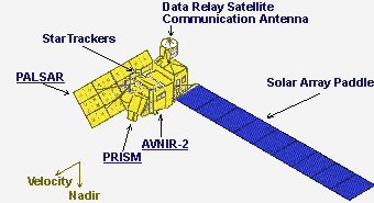

Three remote-sensing instruments boarded on ALOS.
ALOS has four missions :
• Cartography
• Regional Observation
• Disaster Monitoring
• Resource Surveying
The ALOS-1 satellite has completed its mission life in 2011!
 |
PALSAR (Phased Array type L-band Synthetic Aperture Radar) |
| PALSAR is an active microwave sensor for cloud-free and day-and night land observation and provides higher performance than JERS-1’s SAR. This sensor has a beam steerable in elevation and the ScanSAR mode, which allows us to obtain a wider swath than conventional SARs. |
|
 |
PRISM (Panchromatic Remote-sensing Instrument for Stereo Mapping) |
| PRISM is a panchromatic radiometer with 2.5-meter spatial resolution. In order to obtain terrain data including elevation, PRISM has three optical systems for forward, nadir, and backward view. Precise land information can be obtained frequently by PRISM AVNIR-2: Multi-band(color) images, capability of pointing |
|
 |
AVNIR-2 (Advanced Visible and Near Infrared Radiometer type 2) |
| AVNIR-2 is a visible and near-infrared radiometer for observing land and coastal zones and provides better spatial resolution than ADEOS’s AVNIR. It will be used to provide land coverage maps and land-use classification maps for monitoring regional environment. The instrument has a cross track |

For more information about ALOS you can visit following pages:
http://earth.esa.int/ALOS/
http://global.jaxa.jp/projects/sat/alos/
| For more information about ALOS you can visit following pages: http://earth.esa.int/ALOS/ http://www.eorc.jaxa.jp/ALOS/ |
|
|
| For more information about ALOS you can visit following pages: http://earth.esa.int/ALOS/ http://www.eorc.jaxa.jp/ALOS/ |
|
|