The POS AV is also available with an integrated flight management system, POSTrack. POSTrack is the first fully integrated, real-time direct georeferencing and flight management system designed for the airborne geospatial community. Purpose-built to reduce the costs associated with the preparation and implementation of airborne surveys, POSTrack minimizes mission planning and operational workload. Utilizing a combination of specifically developed software and hardware tools, the system combines the best of both technologies with all the functionality necessary to simplify and streamline today‘s aerial survey and remote sensing operations.
Benefits
• Provides an accurate real-time and post-mission solution for all motion variables including sensor-specific Exterior Orientation (EO) parameters using Direct Georeferencing.• Eliminates the requirement for aerotriangulation and a complete ground control survey (often only check points for quality control are needed).
• Streamlines and automates the data workflow and quality
control processes.
• Allows for single stereo model mapping and single photo orthorectification using an existing Digital Elevation Model.
• Improves productivity in traditional aerial mapping applications, which translates into operational time and costs savings, with
increased accuracy.
• Easily integrated with digital cameras, film cameras, Lidar systems, SAR systems, and digital scanners.
• Ideally suited to inhospitable environments and rapid response applications where ground control is not available.
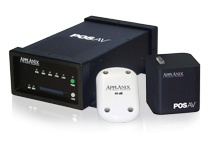
Components
• PCS: POS Computer System. Ruggedized, low-power, light-weight, small format, with built-in logging. Includes embedded state-of-the-art survey grade GPS receiver.• IMU: Inertial Measurement Unit. Ruggedized, state-of-the-art, small format, light-weight, with high measurement rates.
• POSPac: Post-processing software bundle. Includes Carrier Phase DGPS processing, Integrated Inertial/GPS processing, and optional photogrammetry tools for • EO generation, IMU boresight calibration and quality control.
• Optional Integrated Track’air Flight Management System: Mission planning, pilot display, and in-air POS AV and sensor control for maximum in-flight task automation and operational efficiency.